Predicting Hurricane Coastal Impacts, FY21-24 (CLOSED)
Posted: 06/15/2020
Team Planning Letters Due: 07/24/2020; Planning letters are requested but not required, those submitted by the deadline will receive feedback.
Proposal Deadline: 09/30/2020, 5pm Eastern Standard Time
Description:
On behalf of the National Oceanographic Partnership Program (NOPP), the Office of Naval Research (ONR) solicits research proposals under its FY20 Long Range Broad Agency Announcement (BAA) for Navy and Marine Corps Science and Technology N00014-20-S-B001 (https://www.onr.navy.mil/en/work-with-us/funding-opportunities/announcements ). Congress established NOPP via Title II, subtitle E, of Public Law 104-201 to promote the national goals of assuring national security, advancing economic development, protecting quality of life, and strengthening science education and communication by improving knowledge of the ocean. Over twenty agencies participate in the NOPP and are identified on the NOPP website: www.nopp.org
This announcement concerns research on Predicting Hurricane Coastal Impacts of continental US (CONUS) landing hurricanes over the period 2021-2024. All successful applicants will be notified and the NOPP office will provide the 2021 NOPP project announcement on their website. Up to $9 million over four (4) years may be available for this solicitation, subject to appropriation, availability of funds and final approval by the participating NOPP agencies. NOPP funding will be dependent on proposal topic availability and individual agency policies, procedures, and regulations. There will be no classified work funded under this solicitation.
Elegibility Information:
Team efforts are required, for each of the four focal topics. However, offerors must be willing to cooperate and exchange software, data and other information in an integrated program with other contractors, as well as with system integrators, selected by ONR. Every team must be comprised of at least two of the following three sectors:
- Academia,
- Industry (including Non-Governmental Organizations – NGOs), and
- Government (including Federal, Tribal, State and Local)
In forming the required teams, participants should consider the criteria for the NOPP Excellence in Partnering Award (EIP), which has two main purposes:
- Recognize superior efforts among partners in coordinating an exemplary NOPP project and
- Highlight the successes and benefits of NOPP projects to the ocean sciences community.
The evaluation criteria, which exemplify true partnerships and highly successful projects, are:
- Ocean sector diversity among the partners;
- Level of effort/involvement by partners (Are the partners actively and equally involved in the research and/or development of the project?);
- Long-term commitment of the partners beyond the NOPP-funding period;
- The success of the partnership in meeting its project objectives;
- Impact of the effort on ocean research and/or education; and
- Distinguishing characteristics of the partnership that contributed to its success.
All businesses both small and large are encouraged to submit proposals and compete for funding consideration. However, no portion of this announcement will be set aside for Small Business or other socio-economic participation.
Foreign institutions are eligible to apply for support as a partner under this announcement.
Research Description
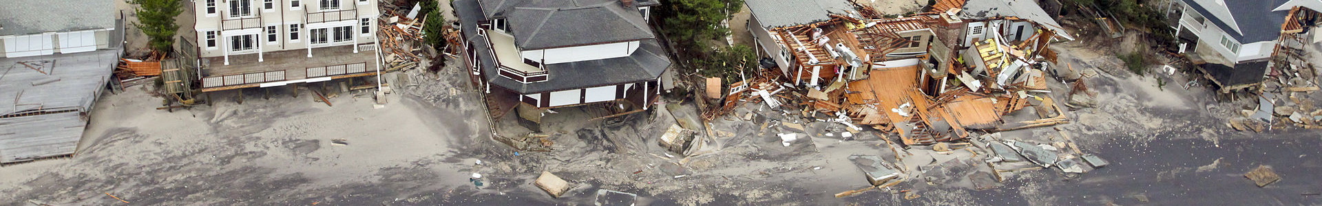
Nearly every year during hurricane season US Gulf and Atlantic coastal communities are threatened by large storms, which can inflict flooding, erosion, coastal breaching and destruction of property and infrastructure. While forecasts of hurricane intensity and track have improved considerably over the last decade, uncertainty remains as to what will actually happen above mean sea level on land as a result. Over the last 4 years, community coastal wave, current and sediment transport models have been used in a hindcasts of CONUS landing hurricanes. These hindcasts (forced by the modeled “best-track” winds) were evaluated quantitatively, including the ability to reproduce wave heights and water levels, and the observed changes on land (erosion, accretion and breaching). The results indicate that if the forecast winds and track are correct, the greatest uncertainties in the coastal impacts are not in the numerical models, but on land, in terms of boundary conditions for elevation, sediment type, vegetation, infrastructure and buildings. As described below, this announcement seeks to begin to forecast these impacts in a research mode during the hurricane seasons of 2022-2024. To tackle this monumental challenge, the NOPP envisions a number of teams each of which are critical to success, and which must work cohesively to produce the forecasts and conduct the quantitative evaluation of performance.
These activities are briefly described below with amplification following and a summary table at the end, including funding levels per task and team.
Task 1) Year 1, the building of a Digital Elevation Model (DEM) and in Years 2-4 regular updates and quantitative post-hurricane impact summaries;
Task 2) New quantitative capabilities in satellite remote sensing for both building a ground-truth DEM and quantitative geophysical measurements during the storms, for comparison to and possible assimilation into model forecasts;
Task 3) In situ measurements to include offshore waves, and both offshore and inland water levels, for assimilation prior to landfall and ground truth evaluations afterward; and
Task 4) Forecasting of wave, surge, sediment transport (erosion and accretion above and below mean sea level), structure interaction and damage.
The FY21 (first year) effort will be to develop the supporting DEM’s; develop quantitative DEM satellite remote sensing techniques for use before, during and after storms; develop methods to rapidly deploy wave (airborne) and water level sensors (likely airborne); and get model’s set up for the entire US Gulf Coast, Florida Coast and Eastern Seaboard, with sufficient nesting capabilities to forecast the above properties during the following three hurricane seasons (CY 2022, 2023 and 2024). It is understood that the DEM’s may not be complete to the needed resolution in the first year, but will be continually updated, with the most frequent updates to include bathymetry and topography, before landfall and quantitative summaries of the damage to infrastructure and buildings post landing.
Goal: During each of the CY 2022-2024 hurricane seasons, provide a single daily forecast of hurricane coastal impacts (see below), beginning five days prior to landfall, for three named hurricanes per season. Data collected after the event (bathymetry/topography, inundation, erosion, accretion, infrastructure & structure damage) will quantify the abilities of the model to forecast the coastal response. A number of teams, across all tasks will funded and will work collectively together to meet the overall challenge. Forecasting teams must provide documented computational capability, priority run-time and storage ability (either dedicated institutional computational assets or those from cloud services), to be eligible. Prior experience indicates that it is roughly 5000 CPU hours, per forecast, using 400 cores and at least 3 dedicated Terabytes of storage.
TASKS
Task 1: Digital Elevation Models (DEM), to include topography and bathymetry (one team to be funded, up to $500K in the first year, followed by up to $200K per year for updates and refinement)
Develop, at the scale of 1-5m, digital elevation models (DEM) of the US coastline subject to land-falling hurricanes that includes; the US Gulf of Mexico coast, the Florida Keys, mainland Florida, and the Eastern Atlantic Seaboard. From the shoreline, these high resolutions need to extend inland 2km and seaward to close out depths (depths of minimal sediment movement). Inland, they can then blend with coarser DEM’s suitable for inundation only, i.e., possible > than 1-5m, and seaward of closeout depths to resolutions sufficient to support wave and current modeling. Where large inland bays are located, focus should start with characterizing the main stems, leaving branches to be added in the later years of the project.
Variables should include:
- Elevation (10 cm) and sediment type
- Vegetation type including root depth
- Structures (construction type/materials) and number of stories/elevation
- Inland water bodies and waterways, lakes, marshes, inlets
- Roads, bridges, boardwalks, and any other man-made alterations, jetties, piers, etc.
To the degree possible, leverage existing public and government databases and develop methods, perhaps AI/ML-based, using remotely sensed satellite data to more rapidly turn such data into geophysically useful fields, e.g., Landsat 8 vegetation data to vegetation type, then root depth and drag coefficients. As NOPP is a partnership at both the sponsor and performer level of industry, government and academia, it may be that, under the guise of national emergencies and disaster prevention and response, that arrangements may be made with commercial entities for use of their databases (e.g., Google Earth, Airbus). At the end of the project, said project databases are to be compatible with existing US Gov’t provided databases and reside in the public domain.
Task 2: Remote Sensing (one team to be funded, up to $500K per year including imagery sufficient to image the entirety of the coastline each year, with localized imagery prior to, during and after any landfall for ground truth purposes)
Develop the ability to produce digital elevation models of the beach, foreshore and backshore from Synthetic Aperture Radar (and/or any other modalities), such that data bases can be rapidly built from space, and measurements of the coast made before, during and after a hurricane. The resolution should match the above databases, at horizontal resolutions between 1 and 5m, and 10cm in elevation (relative to the geoid). Quantitative ground truth/comparison of SAR wind and wave products with the deployable, measured wave and wind field during the storm should also take place.
To the degree possible, leverage existing databases and imagery and develop methods, perhaps AI/ML-based, for use on remotely sensed satellite data to more rapidly turn such data into geophysically useful fields, infrastructure, roads, and buildings and building characteristics.
Task 3: In Situ Measurements (up to two teams to be funded, up to $250K per year including equipment purchase, deployment, recovery and refurbishment)
Air Deployed Wave Buoys: Airborne deployed, real-time satellite reporting (and internal recording) directional wave-spectra buoys in sufficient numbers to entirely encircle a hurricane, with re-seeding to occur on the landward portion, 48 and 24 hours prior to landfall. The real-time measurements are to be used to predict wave heights, periods and directions on an hourly basis, from the hurricane eye, to 300 km to either side of the predicted landfall location. Airborne deployment flights will be provided and should not be included in costs.
Coastal and Inland Water Levels and Wave Measurements: The ability to rapidly [air/helicopter?] deploy water level measurement capabilities along coasts both to seaward and to inland waterways where such bodies exist and back immediately to the backshore of the beach. Real-time satellite reporting (and internal recording) will enable observation and assimilation into models and used to assess breach potential. Directional wave-spectra buoys (as above), will be as well. Airborne deployment flights will not be provided and should be included in costs, if appropriate.
It is expected that much of the equipment will be retrieved after the storm as possible and re-used, though losses are expected. Iridium Satellite SBD cards can be provided for all sensors as needed.
Task 4: Wave, Surge, Sediment Transport (moveable bed), Structure Response Forecasting (WSSTSR Forecast); Up to three teams to be funded, up to $400K per year per team. Only one team will be funded to utilize any one particular model)
COAMPS-TC 1, which is coupled to the Navy Coastal Ocean Model (NCOM), will provide the following variables to each team, updated once daily, beginning 5 days (T-5) from projected landfall.
Using open source community code 2 and supplied boundary conditions 3 from the other teams, for each daily hurricane forecast supplied by COAMPS-TC, forecast the coastal/shoreline waves, currents, sediment transport, coastal erosion and accretion (above and below MSL), inundation, breaches and structure response at human scale (1-5m along and inland), to a distance inland that encompasses all inundation from the seaward side (not from rainfall). Days T-5 and Day T-4 may be probabilistic, but Day T-3 to landfall must be deterministic. These forecasts will be provided to first responders as a research product, not an operational (certified/verified) one. Structural response in this case means to indicate whether a coastal structure will survive the storm, and/or how it will be damaged or compromised.
1 Coupled Ocean Atmosphere Model Prediction System-Tropical Cyclone;
2 e.g., Delft-FM, COAWST, XBEACH, SWAN or other);
3 i.e., bathymetry, winds, waves, digital elevation models (elevation, sediment type, vegetation type, structures, bridges, roads, jetties, structure and structure construction);
Table 1
| COAMPS-TC Supplied Variables, at 4km resolution, hourly, beginning 5 days from projected landfall | |
|---|---|
| 10-m Winds | Surface Relative Humidity |
| Surface Pressure | Surface Wind Stresses |
| 2-m Air Temperature | Long Wave and Short Wave Radiation at the Surface |
| Surface Latent and Sensible Heat Fluxes | Surface Net Radiation |
| Hourly Precipitation | |
In CY22-24, outside of hurricane season, a hind-cast of COAMPS-TC which follows the agreed upon “best-track” will be provided to investigators for use in forcing the storm impact prediction models. These hindcasts will be used to determine strengths and weaknesses of the different models and whether they stem from too few observations, physics-based understanding, numerical implementation, or boundary conditions, etc. These analyses will help to improve the effort for the following season and guide future research investments.
| Task | Number of Teams | Year 1 Funding per team | Year 2 Funding per team | Year 3 Funding per team | Year 4 Funding per team | Total Per Task |
| 1. Digital Elevation Models (DEM) | 1 | $500,000 | $200,000 | $200,000 | $200,000 | $1,100,000 |
| 2. Remote Sensing | 1 | $200,000 | $500,000 | $500,000 | $500,000 | $1,700,000 |
| 3. In Situ Measurements | 2 | $250,000 | $250,000 | $250,000 | $100,000 | $1,700,000 |
| 4. Forecasting (WSSTSR) | 3 | $200,000 | $400,000 | $400,000 | $400,000 | $4,200,000 |
| Total Project Funding | $1,800,000 | $2,400,000 | $2,400,000 | $2,100,000 | $8,700,000 |
Due Dates and Submission Process
Team Planning letters: Due by 07/24/2020. These are requested but not required, any planning letters submitted by the deadline will receive feedback.
The team planning letter should contain a short (three page maximum) technical description of the research to be pursued and an estimate of the costs for the work. The letter should describe the task being pursued, the approach, connections to other programs, and the plans for dissemination of results, a budget and budget justification. It should identify who will participate in the work and their specific contributions.
The team planning letter should have a two page curriculum vitae of the principal investigator (PI) and co-PI’s. The project costs (one page) should be broken down into the following rough categories for each fiscal year: salaries and benefits, equipment, materials and supplies, travel, costs associated with student participation (tuition and fees) and indirect costs. Due to the short timeline of this effort support for graduate students may be requested, but is not guaranteed. Support for postdocs is encouraged.
Finally, the team cover page should provide the project title, the proposed budget for each year with a total, and the mailing address, phone number and email address of the principal investigator. The cover page, any figures, budget and CV’s are not included in the 3 page technical description limit. NOTE: these are not proposals, they are nuggets, please be concise.
The team planning letter should be submitted by e-mail as PDF files to: NOPP@nopp.org and copy Reginald.Beach@navy.mil and Melody.Hash.ctr@navy.mil.
Submissions must not exceed 15Mb.
To more easily highlight your submission as a planning letter, please use the following:
SUBJECT: NOPP Planning Letter: YOURLASTNAME
- Proposal Deadline: 09/30/2020, 5pm Eastern Standard Time. These should be submitted through the ONR Long Range BAA, https://www.onr.navy.mil/en/work-with-us/funding-opportunities/announcements
- A PDF of the announcement is available via: https://www.onr.navy.mil/-/media/Files/Funding-Announcements/BAA/2020/N00014-20-S-B001.ashx
- Proposals submitted should indicate “NOPP, 322, Beach, Reginald” or similar in box 4 of grants.gov, so that they are known to be NOPP related. Proposals from for-profit businesses as the lead, should follow the directions in Long Range BAA, and be sure to indicate “NOPP, 322, Beach, Reginald” somewhere in the materials, so they are properly received.
